
The ability to thoroughly understand the existing site conditions and as-built structures before you begin a project is something that everyone in the AEC industry can appreciate and get on board with. Not only does having complete and accurate project information minimize the risk for rework and project delays, but it can also prevent the project from going over budget. Moreover, having access to the information that pinpoints potential issues and pitfalls before the construction begins is even more valuable. Would you agree?
Well, there’s good news! The use of laser scanning services can address many of these issues that could otherwise be missed during traditional field measurements. Laser scanning technology offers tremendous value addition not just at the beginning of a project but also during construction and after the project has been completed for accurate as-built data, all of which was unheard of until recently.
So, before we dive into the nitty-gritty of laser scanning technology, let’s first understand some of the basics and how you could leverage this cutting-edge technology to your advantage!
What is Laser Scanning?
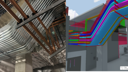
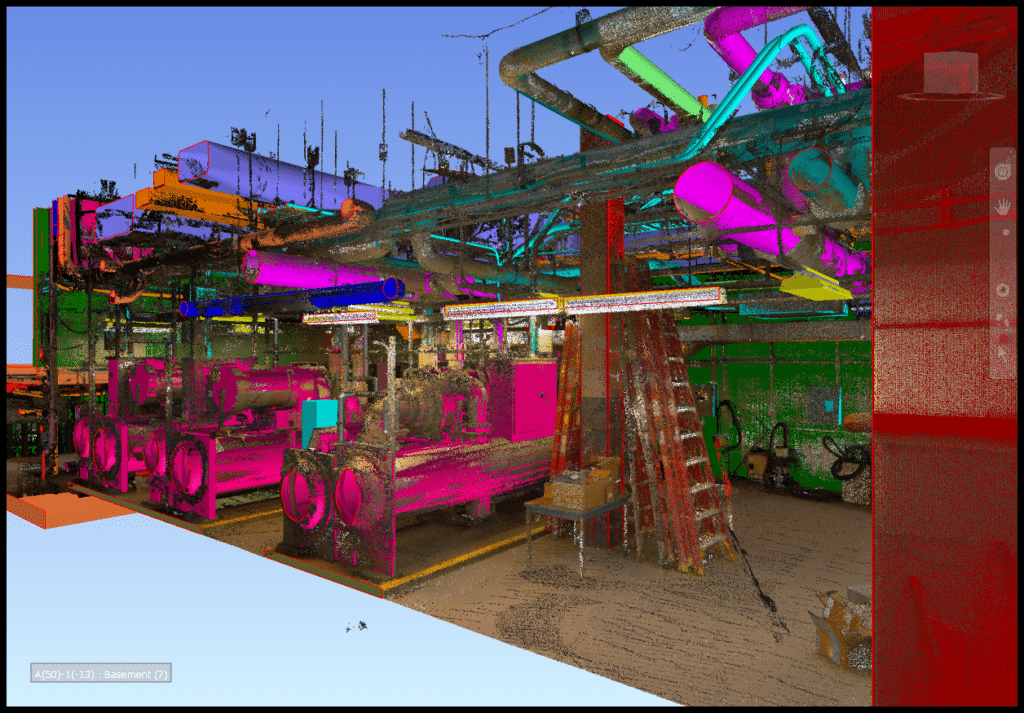
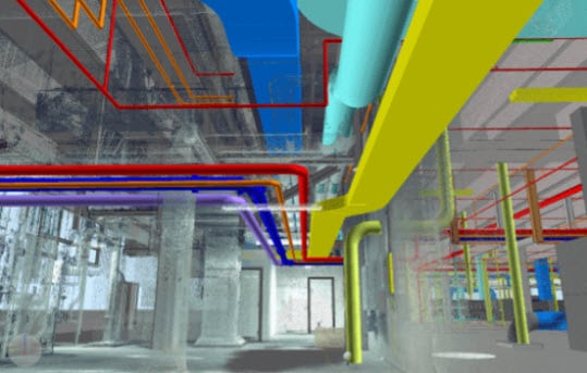
Laser scanning is known by various names – Reality Capture, High-Definition Surveying (HDS), or LiDAR (Light Detection and Ranging). Regardless of what it’s called, laser scanning is a process of capturing and mapping detailed building data using laser beams, which is much like taking a picture with your camera but with a high level of precision with each pixel. The data then created is known as a “point cloud,” which can be used to develop 2D drawings like plans, elevations, cross-sections, 3D textured models and more. We’ll talk more about point clouds in a moment.
Laser scanning technology has been available for decades, but what’s changed is the hardware and software that has enhanced its utility and reduced its cost by providing a more efficient way of getting a job done.
How does Laser Scanning work?
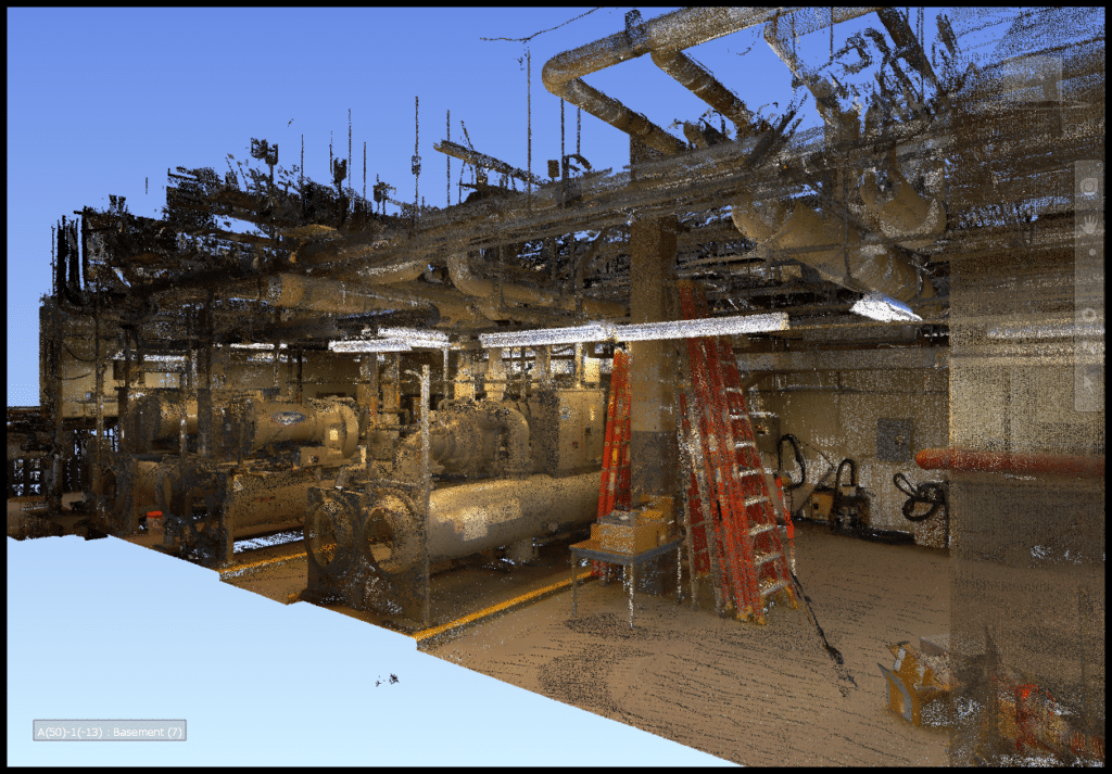
Laser scanning works by putting out millions of lasers to create incredibly accurate 3D renderings of a space, regardless of its construction phase. The system’s sensor cameras continually move around the area to capture every little angle, thickness, and shape, to establish the spatial relationship between an object and its space. Laser scanning can create millions of data points in a matter of seconds that can be traced back to measure a project’s progress.
With the traditional method and equipment, you only get what you measure. But with laser scanning’s correct settings and specs, you can obtain all the information you need and more.
For example, while measuring a room, you’ll obtain the room’s dimensions (length, width, height, wall elevations), furniture layout, location of outlets, fixed elements, if any, and any other visible detail within that space. All this additional information can be available without any extra effort.
Further, laser scanning can be used for designing purposes by adopting the scan-to-BIM application when the project first begins, during construction for MEP coordination, and to create as-built records, retrofits, and renovations.
What are Point Clouds?
A point cloud is a dense group of 3D points that creates an object in the digital space, where each point has X, Y, and Z coordinates. Point clouds contain vast information from an object’s physical location to shape, form, color, reflectivity, and so on. This dataset together represents the spatial measurement as a whole through a process known as ‘registration.’
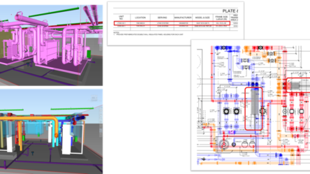
Laser scanning produces a point cloud containing millions of data points that together recreate an accurate, 3D representation of any building. From here, a point cloud can be imported into any major CAD or BIM software for a quick 2D drawing or a 3D rendering. Point clouds can be used for creating detailed floor plans, BIM models, tracking construction progress, and more.
Upsides of using Point Clouds
With point clouds, design professionals can re-visit any site effortlessly, over and over from the comfort of their desks. In addition, design professionals can study the entire site and the structure through virtual tours, 360-degree pictures while taking dimensions, adding notes and comments, all at the same time.
What are some of the major advantages of using Laser Scanning technology?
Achieve enhanced speed and accuracy across all projects while lowering project costs
With laser scanning, architects and designers can improve the accuracy of their proposals, enhance the quality of their projects, reduce their commute time between the office and the job site, and better utilize their time for developing comprehensive, error-free design alternatives. By creating comprehensive files to review off-site, laser scanning reduces the time and costs associated with rework and follow-up site visits.
In addition, with a simple laser scan, design professionals and contractors can achieve exact site dimensions to create well-coordinated drawings that ensure all the structural elements, ductwork, electrical lines, water pipes seamlessly fit together on the first try.
Laser scanning creates millions of data points per second while capturing precise geometric details of even the most complex structures, thereby significantly reducing the time required in measuring the field conditions and boosting overall productivity.
Create integrative workflows and streamline coordination
Laser scanning helps create smart digital realities that can assist you to make informed decisions, evaluate outcomes, track and measure efficiency and productivity.
By implementing the scan-to-BIM technique, design professionals can easily spot errors and compare different stages of a project in the BIM environment. It also makes it convenient to use modern manufacturing applications like 3D printing and off-site material prefabrication.
In the era of remote work, digital files allow all stakeholders to effortlessly access all information in real-time for collective decision-making, problem-solving, and better coordination.
Gain insight into existing conditions and easily build 3D models
Scanned data offers valuable insight into existing site conditions that can be viewed in real-time for on-the-spot decision-making if required. Thorough and reliable information can reduce the occurrence of potentially expensive mistakes and rework. Also, laser scanning offers access to existing plumbing and electrical work concealed behind the drywall for accurate future reference.
In addition, scanning enables you to thoroughly understand a site and create accurate 3D models of large-scale projects in a short span that identifies and prevents errors, saves money, and reduces manual labor. Today, laser scanners can work with site-embedded sensors to monitor a project’s progress and performance.
Challenges with implementing Laser Scanning Services
From the description above, it’s evident that laser scanning technology has a wide range of benefits. But like every technology, laser scanning too has its share of shortcomings despite its significant payoff. Let’s see what some of these are:
Implementing laser scanning services might have a higher upfront cost, but it helps lower the overall project cost when done right.
Laser scanning relies on skilled and trained professionals to achieve the best results. Offering employee training to bridge the skill gap can add to the upfront costs mentioned above.
Laser scanning can be used to produce detailed drawings for any desired location. But to get the best outcome, it’s beneficial if the operator is familiar with the given site.
Final Thoughts
Until recently, laser scanning might have been a relatively new technology adopted by only some market leaders, but today many are starting to understand its benefits around time management, accuracy, risk mitigation, comprehensive workflows, and more. As the technology continues to evolve, it’s emerging as a popular choice among AEC companies across the country.
Laser scanning is a powerful tool that can be implemented through various stages of construction and can minimize expenses incurred due to rework and change orders. Laser scanning can help create synergy within the project when paired with skilled survey teams and BIM integration.
So, why not create your best project yet by leveraging the power of millions of accurate data points at your fingertips?
At ENG, we use the most sophisticated scanning hardware to produce as-built field measurements for any given facility. Further, we can process that data to deliver finished 2D drawing or 3D model files ready to use for our clients. With our real-world knowledge and years of experience, we can deliver the best-in-class results that meet our client’s vision and goals.
Are you interested in implementing point clouds and laser scanning services for your next project? Get in touch with us today to find out how we at ENG can best assist you!
ENG
For more information, contact us!
E-mail: eng@engbim.com
Call us: (949) 340-6924